Storm Jocelyn: Public asked to 'consider if your journey is necessary' and 'be aware of the risk of fallen trees, branches or other debris' as we are battered by second storm
and live on Freeview channel 276
In a statement the DFI adds that ‘where roads are closed people are reminded to adhere to road signs and follow any diversions in place’.
‘Ongoing industrial action may disrupt the Department’s response to the clear up operation however we will endeavour to clear roads as quickly as possible.’ it adds.
Advertisement
Hide AdAdvertisement
Hide AdThe statement says that multi-agency partners including the PSNI, NIE, the Department for Infrastructure and other emergency response and public sector organisations have continued to meet and respond to the impacts of Storm Isha and to prepare for Storm Jocelyn which arrives this afternoon.
They say that all of these agencies have been working round the clock to clear roads and restore electricity as well as to deliver other vital public services in very challenging conditions.
Storm Jocelyn is expected to bring strong winds from 4pm today and a yellow Met Office warning has been issued and will remain in place until 1pm on Wednesday.
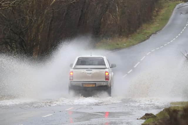
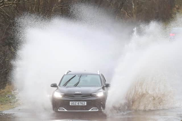
The clear-up operation following Storm Isha continues, to address the remaining obstructions on the road and significant interruptions to electricity supplies.
AND further disruption is expected.
Advertisement
Hide AdAdvertisement
Hide AdThis advice comes as NIE Networks’ engineers and emergency crews continue to work to restore as many customers as possible.
There are currently approximately 6,000 customers without supply.
Customers can report a power cut or any incidents of damage to the electricity network on the NIE Networks Customer Helpline on 03457 643 64
The public are reminded that they should not approach broken power lines or damaged poles or electrical equipment and to please report any damage immediately.
Advertisement
Hide AdAdvertisement
Hide AdAnd Health services continue as normal across Northern Ireland. But in the event of an emergency for life threatening conditions always call 999. For urgent care or minor injuries please contact your local Phone First service. There may be some delays to community care services due to ongoing road closures.
The advice adds that extreme care must be taken when working with wind fallen /damaged trees as they may be unstable with the risk of crushing for people involved in cutting and removing them; Safety during clearing of storm damaged / fallen trees | Health and Safety Executive for Northern Ireland (hseni.gov.uk).
And members of the public should continue to report incidents of flooding to the flooding incident line on 0300 2000 100. Calls taken by the incident line staff are passed to the relevant responding Agency.

The latest yellow weather warning for wind begins at 4pm today (Tuesday).
Advertisement
Hide AdAdvertisement
Hide AdStorm Jocelyn is not expected to be as severe as Storm Isha, but the Met Office has warned of gusts up to 65mph (104km/h).
There is a possibility of even stronger winds in more exposed locations.
What should homeowners do?
- Check if your property could be at risk of flooding. If so, consider preparing a flood plan and an emergency flood kit.
- Give yourself the best chance of avoiding delays by checking road conditions if driving, or bus and train timetables, amending your travel plans if necessary.
- People cope better with power cuts when they have prepared for them in advance. It’s easy to do; consider gathering torches and batteries, a mobile phone power pack and other essential items.
- Be prepared for weather warnings to change quickly: when a weather warning is issued, the Met Office recommends staying up to date with the weather forecast in your area.
According to the Met Office, Storm Jocelyn will bring strong winds and rain to Northern Ireland and much of Britain.
They say that ‘a strong jet stream is pushing another large-scale, low-pressure system from the Atlantic across northern Scotland bringing wet and windy weather for Tuesday night and into Wednesday for much of the northern half of the country’.
Advertisement
Hide AdAdvertisement
Hide Ad‘Amber and yellow National Severe Weather warnings for wind have been issued covering much of the UK together with yellow warnings for rain covering parts of western and southern Scotland, and northwest England.’ a Met Office spokesman added.
Met Office Chief Meteorologist, Steve Willington, said: “Although this system will be a step down relative to Storm Isha, with the damage and clean up still underway, we could potentially see more impacts from Storm Jocelyn.
“Outbreaks of heavy rain on Tuesday could bring rainfall accumulations of 15 to 20 mm quite widely with 40 to 50 mm over higher ground in southwest Scotland, the Scottish Highlands and parts of northwest England.
"Wind gusts are expected to reach 55 to 65 mph across northwestern Scotland while there is potential for winds to gust to 75 to 80 mph in a few places, in particular exposed parts of the Western Isles and coastal northwest Scotland early on Wednesday morning.”
Advertisement
Hide AdAdvertisement
Hide AdThe winds will gradually ease through the Wednesday and as we head through the rest of the week the weather continues to look changeable, with the drier and most settled conditions towards the south and east, and the most unsettled (wettest and windiest) conditions expected in the northwest.
Temperatures are expected to remain mild or close to average for the time of year.
Martin Thomson, National Operations Manager for Resilience at Transport Scotland said: “The trunk road network is recovering well from the worst impacts of Storm Isha. Some roads and bridges do remain disrupted and so please continue to check before you travel until conditions improve and the clear-up is complete.
“Focus will soon shift to the next named storm, Jocelyn, for later this week, and preparations are already underway with rail, aviation and ferries colleagues to ensure we are as ready as we can be.
Advertisement
Hide AdAdvertisement
Hide Ad“The public can play its part and plan ahead by visiting www.traffic.gov.scot. Staff from our trunk road operating companies will be patrolling the network and undertaking inspections to respond quickly to any further treefall or blocked drains. Their proactive efforts in terms of branch cutting and drain clearing at vulnerable locations has helped minimise disruption in the past.
“Across the wider network, we can expect to see more delays and cancellations with ferries, flights and rail from Tuesday into Wednesday morning. Please check with your public transport operator for the latest information and your local authority and Police Scotland for the latest information on local roads.”